The problem with the standard sunrise viewpoint at Gunung Bromo is not the view itself. It’s that everyone knows about it. By five in the morning, the ridge at Penanjakan is dense with bodies, tripod legs intersecting like pick-up sticks, and the sound of idling jeep engines rising through the cold air. I stood there once, early on a Tuesday in the dry season, and watched the same mist rise over the same caldera that appears in every second photograph of East Java — a magnificent sight, certainly, but one that feels more like a product than a place.
What I wanted was the version that the brochures don’t show.
This is not a complaint about popularity — tourism is the livelihood of the Tengger villages that ring the caldera, and the morning pilgrimage to Penanjakan puts food on tables across the region. It’s simply an observation about what gets missed when a single vantage point becomes the only story. The Bromo massif is enormous, its caldera stretching close to ten kilometres across, maybe more, and the terrain around it is folded and ridged in ways that create different windows onto the same landscape. Some of those windows are visible only to people who walk, not ride. Some are visible only to people who know exactly where to turn off a dirt track at the right hour.
I found my way to one of them through a series of conversations that started at a warung in the village of Cemoro Lawang, the last settlement before the sea of sand. The woman running the place, Ibu Rini, had been serving noodles and sweet tea to climbers for about eighteen years. She watched me unfold a map one afternoon and asked, in the casual way of someone who has seen a thousand visitors make the same assumptions, whether I planned to go where everyone goes.
“Penanjakan is fine,” she said. “But if you want to see the mist settle, you need to be on the other side.”
She drew a rough line on the edge of my map — not a marked trail, just a gesture that indicated direction. “Past the whispering sands. Before the turn to the lava fields. There is a gap between two ridges where the fog pools before it clears.”
I thanked her, folded the map, and spent the rest of the afternoon trying to interpret a few pencil scratches on paper.
The next morning, I found nothing. The gap between two ridges, as far as I could determine from ground level, could describe almost any point along the caldera rim. I wandered for an hour through the fine ash of the sea of sand, watched the sun climb over the crater’s edge, and returned to Cemoro Lawang with a phone full of mediocre photos and a growing respect for how easily the landscape can keep its secrets.
The second attempt was closer. A motorbike taxi driver named Made offered to take me partway up an unsealed track that branched off the main road about two kilometres before the Penanjakan parking area. The track was steep, rutted, and barely wide enough for a single vehicle, but it climbed through a stand of pines that thickened until the sky was visible only in patches. Made stopped at a point where the track opened onto a rocky shelf, gestured vaguely toward the east, and said, “From here, walk.” Then he turned the bike around and left, the sound of the engine fading into the trees.
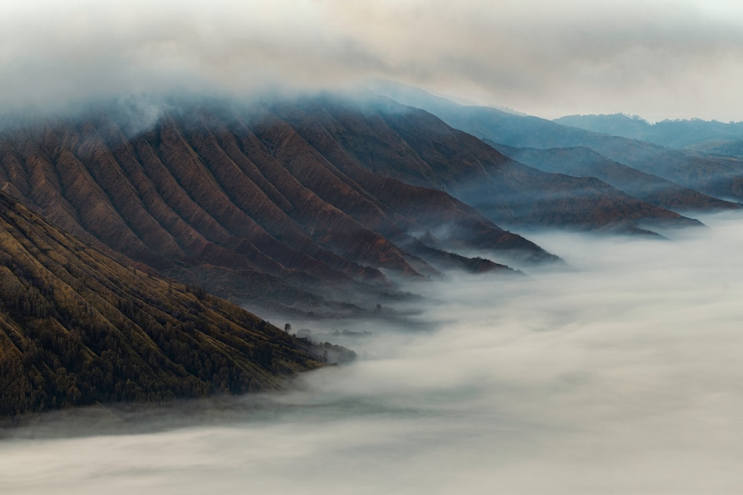
I walked for perhaps twenty minutes along a ridge that grew narrower as it went, the drop on either side becoming steeper than I was entirely comfortable with. The mist was still low, thick enough that the caldera remained invisible, and I almost turned back twice. But the ridge eventually ended at a small plateau, maybe eight metres across, covered in moss and scattered volcanic stones. The mist below me was not a flat blanket — it was moving, swirling in slow currents that revealed and then concealed the crater floor in a rhythm that felt deliberate, like breathing.
I sat down and waited.
What happened next was not dramatic. The sun rose behind the bulk of Mount Semeru to the south, and the light shifted from grey to gold in increments too gradual to catch at any single moment. The mist began to thin from the top down, as though someone was peeling a layer of cotton wool off the landscape. The caldera emerged piece by piece: first the dark slope of Bromo’s inner cone, then the flat expanse of the sea of sand, then the distant wall of the Tengger massif beyond. For about ten minutes, the view from that plateau was entirely my own.
The mist does not lift uniformly. It gathers in hollows, retreats, advances again. It creates the illusion of solid ground where there is only air, and it can swallow a mountain that stood visible thirty seconds earlier. What makes the hidden viewpoint worthwhile is not the absence of other people, though that helps. It is the chance to watch this process unfold at its own pace, without the pressure of a bus schedule.
I spent two more mornings on that plateau. The first of them was ruined by cloud cover so dense that I saw nothing beyond five metres for the entire hour I waited. The second morning was better, though again different: a thin haze that filtered the light into something almost blue, the caldera looking less like a geological feature and more like a painting of one. I photographed none of it well. That is another thing the coverage rarely admits — sometimes the best viewpoints yield the worst images, because the conditions that make the view interesting do not translate through a lens.
The practical path to this spot is straightforward once you know it exists, though I would not recommend attempting it without a local guide unless you have significant experience reading volcanic terrain. From Cemoro Lawang, follow the main road toward Penanjakan for about three kilometres. Just after a sharp left-hand bend, look for a narrow track on the right, marked by a pile of dark stones about waist-high. The track climbs for roughly one kilometre, becoming more eroded as it rises, until it reaches a clearing where three pines grow in an uneven cluster. From there, a footpath bears east along the ridge. The plateau is at the end of that path, about fifteen minutes’ walk. Do not attempt this in wet weather — the volcanic soil becomes slick and unstable, and the drop on either side is genuine.
I asked Ibu Rini later why more visitors did not seek out the alternative routes. She shrugged. “Most people come for one sunrise. They read about Penanjakan. They book a jeep. They don’t have time to search. And the guides — many of them only know the main spots.” She paused. “If you want the other places, you need to ask the old drivers. The ones who have been here before the road was paved.”
That detail — the age of the road — turned out to be more relevant than I initially understood. The sealed road to Penanjakan was completed only in the early 2010s. Before that, reaching the main viewpoint required a longer, rougher journey on foot or by horseback, and the range of accessible viewpoints was determined more by terrain than by infrastructure. The older guides, the ones who worked the trails before the jeeps arrived, carry a mental map of the caldera that bears little relation to the one printed in tourist brochures. They know which ridges catch the first light in the dry season, which gullies funnel the mist in specific wind conditions, and — crucially — which paths disappear under vegetation if not used for a season.
I found one of those older guides by accident. His name was Pak Warsito, and he had been taking people onto the caldera since 1998, when the only way to cross the sea of sand was on foot or by pony. I met him not through any agency but at a small stall near the Bromo parking area, where he was drinking coffee from a plastic cup and watching the jeeps unload their passengers. I mentioned Ibu Rini’s sketch. He laughed, not unkindly, and said, “That’s a good place. But she only knows half of it.”
He spent the next twenty minutes — and two more cups of coffee — describing a route that started from a different village entirely, on the far side of the caldera. The route involved a pre-dawn walk through a pine forest, a descent into a dry riverbed, and a final scramble up a scree slope that, according to him, offered a view of three volcanic cones at once: Bromo, Batok, and Semeru in the distance. He offered to take me the following morning for a price that seemed absurdly low — roughly ten dollars, or something like that.
I accepted. The walk was harder than he had described, the scree slope looser and longer, and I arrived at the viewpoint with ash in my shoes and sweat drying on my skin. But the view was as he had promised: the three cones arranged in a line across the horizon, the mist curling between them like river water, and no other human being in sight. We sat in silence for a long time, Pak Warsito smoking a clove cigarette and occasionally pointing at something I had not noticed — a hawk riding a thermal, a patch of green where water had pooled, the faint shape of a village on the caldera’s outer slope.
“You see,” he said, “most people come to Bromo to take a photo. They don’t come to see it.”
From a jeep, on a sealed road, at a crowded viewpoint, Bromo is a spectacle — something to be watched from a safe distance and then walked away from. From a hidden ridge, after a difficult walk, in the company of someone who has watched the same mist lift for twenty-five years, it becomes something else: a place that demands something of you, even if that something is only the willingness to sit still and let the light change.
The hidden viewpoints do not have signage. They do not appear in Google searches. They exist in the memories of people who have been walking this landscape long enough to know that the best seat in the house is not always the one with the most comfortable access.
On my last morning in the area, I returned to the first plateau, the one Ibu Rini had drawn on the map. The mist that day was unusually thick, and the caldera remained hidden until well after seven. I waited longer than I should have, until the sun was already high and the light had flattened into the harsh white of late morning. The mist finally broke, but the view was not the one I had come for. The plateau was clouded, the distant peaks invisible, the whole landscape reduced to a soft grey expanse that seemed to have no edges.
It was, in its own way, the best view of the trip. Not because it was beautiful — it was not, by any conventional measure — but because it forced a different kind of looking. Without the dramatic sunrise, without the layered peaks, without the photo-worthy composition, all that remained was the simple fact of being there, on a quiet ridge, watching the world do what it does when no one is watching.

📷 Photos: Rowan Heuvel (Unsplash), Rowan Heuvel (Unsplash)