The Trail the Maps Don’t Name
The Trail the Maps Don’t Name
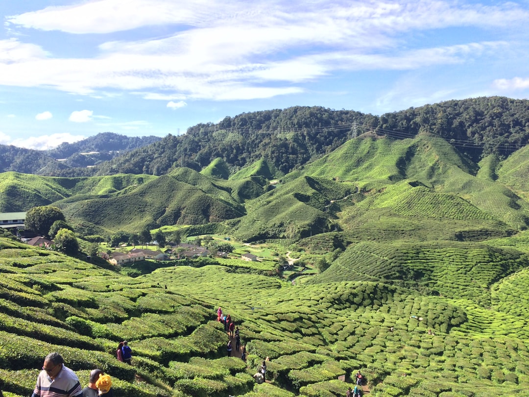
Most visitors to the Cameron Highlands arrive expecting an orderly landscape. Neat rows of green tea bushes, a visitor center with packaged product, a viewing platform with railings. Gunung Brinchang gets the crowds. The Boh Tea plantation at Sungei Palas gets the tour buses. But the highlands also contain something else: abandoned tea terraces, slowly reclaimed by secondary jungle, along a trail that doesn’t appear on the official map sold at the tourism office in Tanah Rata.
The path begins behind a row of shophouses in Brinchang, past a disused water tank and a concrete drain where leeches wait in dry leaf litter. Within fifteen minutes, the road noise drops away entirely. Two hundred meters in, the terraces appear through the undergrowth: stone retaining walls, collapsed at intervals, supporting flat platforms where tea bushes still grow wild, untended for at least two decades by local reckoning. The plants have gone leggy, sending branches upward at odd angles, but the leaves remain dark green and glossy. A person could pick them and process them at home, though the flavor would be unpredictable.
The trail follows a ridgeline above the town, then drops into a valley that opens onto nothing but cloud forest. “That was the last plantation,” according to a guide based in Tanah Rata, who has walked the route perhaps forty times. “After the road went in on the other side, they stopped maintaining these. The companies just left.” The name of the companies has been forgotten, or wasn’t shared. What remains is a landscape that feels abandoned mid-sentence.
The Shape of Neglect
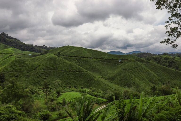
Abandoned tea looks different from working tea. The bushes lose their hedged uniformity and grow into small trees, their trunks thickening where pruning once kept them thin. Moss covers the lower branches. Along the terraces, wild raspberry canes have established themselves in the gaps, their thorns catching at clothing. It’s not a pristine ruin. It’s a working ecosystem that has absorbed a human structure back into itself.
The soil underfoot is different, too. On the working plantations, the ground is compacted from regular foot traffic and machinery. Here, the earth is soft and dark, with a layer of decomposing leaf litter that muffles footsteps. In the wet season, which runs roughly October through December and again March through May, the trail becomes slippery in a specific way: not mud that cakes onto boots, but a thin, greasy film over clay that provides no traction at all. A pair of hiking poles helps, though many locals simply walk it in sandals, trusting decades of familiarity with the terrain.
A detail that catches first-time visitors off guard: the silence. The working plantations have the constant hum of machinery — leaf-cutters, trucks, the distant compressor of a processing facility. On this trail, the dominant sound is the rustle of leaves in the breeze, punctuated by the call of mountain bulbuls. The lack of human noise feels less like peace and more like evidence of something that stopped happening here.
What the Trail Takes
The route requires about four and a half hours at a moderate pace, including stops. It gains roughly four hundred meters of elevation over the first hour, then descends through the abandoned section before looping back via a forest service road. The path is not marked with official signage. Orange tape tied to branches marks turns, placed by hikers who came before, and some of the tape has faded to near-invisibility. Anyone walking this trail should download the GPS track beforehand — phone reception is absent from the point where the valley closes in until the trail re-emerges near the Kampung Raja road.
Leeches are present year-round, but particularly active during and immediately after rain. They tend to wait on broad leaves at ankle height, and they can sense body heat through thin socks. A leech that attaches below the knee is often noticed only when the wound begins to bleed freely hours later. Salt or a cigarette lighter removes them, though neither is pleasant to carry on a sweaty hike. A better option: leech socks worn over trouser cuffs, available at outdoor shops in Tanah Rata for around RM 25.
One section of the trail, roughly twenty meters long, runs along a terrace edge where the retaining wall has collapsed entirely. The path narrows to a single boot-width, with a drop of about six meters into dense undergrowth on one side. A hiker slipped here in early 2023, according to the guide in Tanah Rata, and required assistance from the local fire department to be carried out. The incident has not led to any trail improvements. The trail remains what it has always been: something that people find for themselves and pass along by word of mouth.
The Midday Problem
Most online accounts of this trail recommend starting early — before eight, before the sun clears the ridge. It’s reasonable advice, but it skips a genuine problem: the light at that hour, filtering through the tree canopy at a low angle, creates high-contrast conditions that make photography difficult. The abandoned terraces are best photographed between 10 AM and 1 PM, when the sun is directly overhead and the shadows from the overgrown bushes fall straight down rather than casting long diagonals across the stonework.
The trade-off is heat. By noon in the dry season, the temperature in the valley bottom can reach 28°C with humidity around 85 percent. The air feels heavy in a way that makes steady uphill walking uncomfortable. A two-liter water bottle is the minimum for the full loop; three liters is better. There is no reliable water source along the trail, despite a seasonal stream shown on some older maps. A local hiker, encountered on the trail during a visit in July, carried a one-liter bottle and ran out two kilometers from the end. He had to wait for his companion to return from the car with more water.
There is an argument for starting at 10 AM, accepting the midday heat, and spending the first hour on the uphill section before the sun reaches full strength. The abandoned terraces are then encountered at the right time for the best light, and the descent through the forested return leg is mostly shaded by afternoon. The guide in Tanah Rata does not recommend this approach because it means hiking in the hottest part of the day, but he also acknowledges that the people who start at 7 AM often miss the best views. “They take a picture of the tea plants and they leave,” he said. “They don’t stay long enough to see the place change.”
A Rusted Cable and a Concrete Slab
Scattered through the abandoned section are remnants of the original operation: a rusted steel cable that once ran a hillside tramway, now half-buried in leaf litter; a concrete foundation, roughly two meters square, that appears to have supported a small processing shed; and a single corrugated iron sheet, perforated with rust holes, propped against a tree. None of these items are marked or protected. They are simply there, slowly degrading, and it’s unclear whether they will survive another decade or if the forest will pull them under entirely.
A local heritage enthusiast, who has documented the highlands’ tea history informally since 2015, estimates that at least four abandoned plantation sites exist within the Cameron Highlands district, with this trail accessing the largest. The others are accessible only by private access roads, or lie on land now owned by palm oil concerns that do not welcome visitors. This trail, then, is the only one that offers what he calls “walk-in access to a closed chapter” — a chance to see the highlands as they looked before the tourism boom reshaped the main valleys.
The tea industry in the Cameron Highlands peaked in the 1960s, when more than a dozen companies operated here. Today, three major plantations remain, and most of the smaller ones have been converted to vegetable farms or fallow land. The terraces along this trail were abandoned when the access road was rerouted to serve a newer plantation on the other side of the ridge, making the cost of maintenance uneconomical. The tea plants, however, did not die. They adapted. And now they grow in a state that is neither wild nor cultivated, but something in between — a living archive of an economic decision made decades ago.
The Wrong Kind of Mist
The Cameron Highlands are famous for their fog. It rolls in most afternoons, starting around 2 PM, and can reduce visibility to under twenty meters within an hour. On the working plantations, the fog adds atmosphere. On this trail, it creates a navigation hazard. The unmarked sections of the path become harder to read, and the orange tape markers vanish into the gray. A hiker caught in heavy fog on this trail would need to rely entirely on their GPS track, with no visual backup.
During a visit in November, a group of three hikers encountered fog so thick that they lost the trail for about forty minutes. They sat on a stone terrace and waited, watching the fog thin, then thicken, then thin again. Eventually they found the trail again by following the sound of water: a small stream that crosses the path about three-quarters of the way through the loop. They were not lost in a dramatic sense — they knew roughly where they were — but they could not move forward safely until the fog lifted enough to reveal the next tape marker. They emerged from the forest at 4:15 PM, two hours later than expected, with headlamps unused but carried.
The fog is not the problem itself, the guide said. “The problem is people who think they can walk out anytime and get back before dark. They don’t respect the fog. They don’t plan for it.” He carries a small compass and a paper map of the ridge system as a backup, printed from an online source and laminated. The map is not to any official standard, but it shows the shape of the valley and the relative positions of the abandoned terraces. It’s enough, he said, to get someone out if the GPS dies.
The Return Leg and a Curry Puff
The forest service road that forms the return leg of the loop is less interesting than the outward section, but it serves a purpose: it provides a clear, wide path that requires no navigation, allowing the mind to wander. The road passes through secondary forest that was logged in the 1980s and left to regrow. The trees here are younger and thinner than in the primary forest, with a dense understory of ferns and ginger plants. The ground is carpeted with fallen leaves that crunch underfoot instead of muffling sound.
About halfway along the road, there is a small clearing where a vegetable farmer has established a plot of cabbage and spring onions. The plot is irrigated by a system of black pipes that run from a tank higher up the slope. The farmer is often present during the day, and has been known to wave at passing hikers without stopping his work. He does not speak English, and the hikers who pass do not speak his dialect. The interaction, such as it is, consists of a nod and a continued walking pace.
The final kilometer of the return leg passes a small Buddhist temple, built in the 1990s, with a prayer hall and a bell that visitors are permitted to ring. The path emerges onto a paved road about two hundred meters from where it began, and the sound of traffic from Brinchang returns. The transition is abrupt: one moment, silence and moss and rusted cable; the next, a car horn and the smell of frying dough from a roadside stall. The stall sells curry puffs for RM 2 each, and a cold 100 Plus for RM 3.50. These prices have not changed in at least three years, according to the woman who runs the stall, and she sees no reason to raise them.
The walk ends with a greasy pastry and a drink that was colder fifteen minutes ago, standing on a roadside that doesn’t look like it leads anywhere special. The abandoned terraces remain where they are, slowly returning to forest, visited by a handful of people each week.
📷 Photos: kira on an adventure (Unsplash), Abdelrahman Ismail (Unsplash)