From Christchurch to Wellington: A South Island Alpine & West Coast Campervan Voyage: Day 1 to 5
The man at the Jucy rental desk in Christchurch handed over the keys with a practiced smile and a laminated map already marked in blue highlighter. “You’ll want to stick to the eastern route,” he said. “State Highway 6 through the Lewis Pass is faster. The West Coast road’s unpredictable this time of year.” I took both key and map, nodded, and drove west anyway. By early afternoon, rain was hitting the windshield of the five-berth campervan with the kind of sideways insistence that makes you reconsider every decision you made that morning, including whether you should have eaten that second slice of airport quiche.
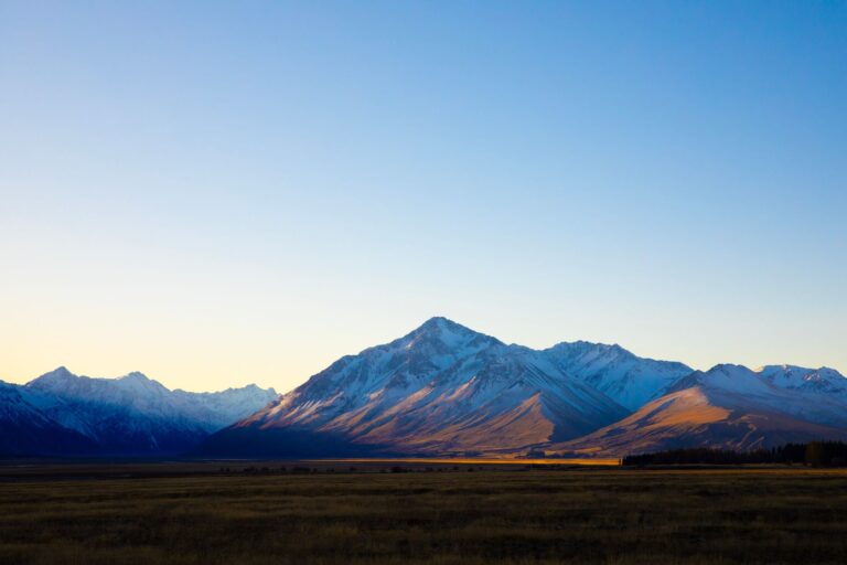
The drive from Christchurch to Arthur’s Pass takes roughly two and a half hours if you’re efficient. I was not efficient. I stopped at the Sheffield Pie Shop because someone on a forum had written the phrase “flaky crust” with the kind of intensity usually reserved for matters of national security. The pie cost $7.50 — a mince and cheese that sat in my lap, steaming, as I watched the Canterbury Plains tilt upward into foothills and then into something that was no longer plains at all. The mountains don’t announce themselves. They creep in, one ridge at a time, until suddenly the landscape is vertical and you’ve forgotten what flat ground looks like.
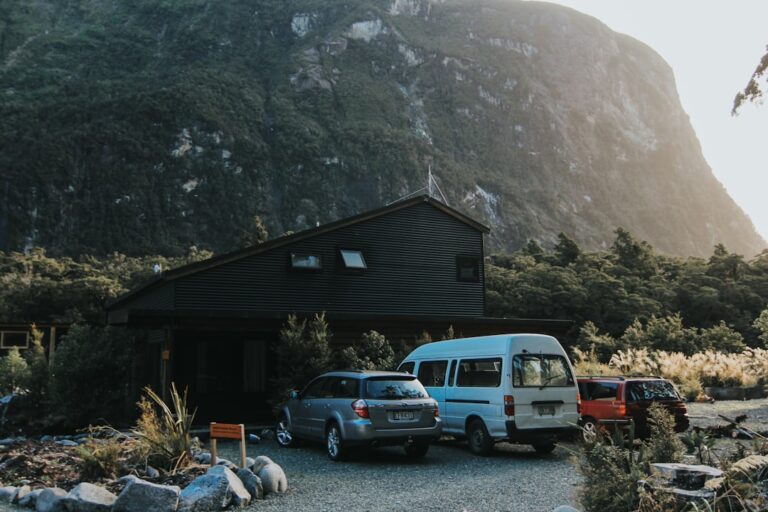
Arthur’s Pass Village barely qualifies as a village — a handful of buildings, a petrol station that closes early, and a DOC visitor center that had just run out of the topographical map I wanted. “Try the hostel next door,” the woman at the counter said. “They sometimes keep a few.” The man at the hostel was named Pieter, South African, working the winter season at a ski field further north. He didn’t have the map but offered me tea and a warning about kea. “They’ll take anything shiny,” he said. “Sunglasses, camera lens caps, your car keys if you leave them on the dashboard.” I tied my keys to my belt loop and decided to hike up to the Devil’s Punchbowl before dark.
The walk is twenty minutes from the car park, uphill on a well-formed track, and the waterfall itself is 131 metres, but the detail nobody mentions is the sound. Standing at the base of a waterfall that size isn’t loud in the way you expect. It’s a physical pressure, a low hum that settles into your chest and stays there for hours afterward. I sat on a damp rock for long enough that my legs went numb, watching the water hit the pool and vanish into white spray. A couple from Germany arrived, took three photos each on their phones, and left within four minutes. I stayed another fifteen, not because I was having a profound moment but because I couldn’t feel my legs and standing up seemed like a project.
The overnight temperature in Arthur’s Pass that night was four degrees Celsius. The campervan’s diesel heater hummed in fits and starts, and I woke once at 3 a.m. to the sound of something scratching at the door — a possum, I later decided, or a kea testing the rubber seals. There’s a specific vulnerability to sleeping in a metal box in a valley surrounded by mountains, where the nearest town with a proper mechanic is two hours away. I lay awake listening to the wind and wondering if I’d locked the gas locker properly. I had.
Morning brought fog and a decision. The direct route — State Highway 73 back to the eastern plains, then down to the Mackenzie Country — would have been sensible. The West Coast road, State Highway 6 through the Otira Gorge, was the one the rental agent had warned about. It was also the one everyone at the DOC visitor center had mentioned in passing, the way locals talk about a difficult relative: with affection and a certain wariness. I drove into the gorge at 9 a.m., the fog so thick I could barely see the yellow centreline, and for twenty minutes I gripped the steering wheel at ten-and-two while the road narrowed to barely one lane in places. There are no guardrails on certain sections of the Otira Gorge. I don’t mean there are old, rusty guardrails that need replacing. I mean there is nothing between your tyres and a long drop except a prayer and good suspension.
The fog lifted just before the town of Hokitika, as if someone had thrown a switch. The West Coast sky turned a pale, tentative blue, and I pulled into the Hokitika Beach Cafe at 10:30 for a flat white and a moment of gratitude for not having driven off a cliff. The cafe was nearly empty — a man reading a newspaper, a woman on a laptop, the barista wiping down the counter. My coffee cost $5.50 and came with a small piece of shortbread on the saucer, a detail that felt disproportionately generous given the morning I’d had.
Hokitika is one of those towns that most itineraries treat as a refuelling stop, and those itineraries are wrong. The driftwood sculptures on the beach are the kind of thing that sounds twee on paper — local artists building temporary structures from wood washed ashore — but in person, the scale surprises. One piece, a whale’s skeleton maybe twelve metres long, had been assembled from logs and branches so precisely that I could count the ribs. The tide was coming in, and a local photographer was capturing the water wrapping around the base of the sculpture. “They only last a few weeks,” she said, not looking up from her camera. “Then a storm takes them, or someone collects the wood for fire. That’s the point.”
I spent an hour on the beach, long enough for the wind to turn my cheeks red and my hands cold. A pair of dog walkers passed, their Labrador chasing a piece of driftwood I threw, and we stood in silence watching the waves for a moment before they moved on. It’s the kind of interaction that happens constantly on the West Coast — brief, wordless, and entirely unremarkable. Nobody is selling you anything. Nobody is asking for a photo. Strangers simply exist alongside you, doing their own version of the same thing, and then they’re gone.
I had booked a powered site at the Hokitika Holiday Park, $18 for the night, with access to a kitchen that smelled faintly of bleach and old toast. I cooked pasta with a jar of tomato sauce I’d bought in Christchurch, ate it sitting on the campervan’s step, and watched the sky turn the particular shade of pink-grey that the West Coast does better than anywhere else I’ve seen. A British couple in the next site over were having a loud disagreement about whether to push through to Franz Josef the next day or stay an extra night. I ate my pasta and stayed out of it.
The drive from Hokitika to Franz Josef the next morning took just over an hour, and the landscape changed again. The coastal flats gave way to rainforest — actual temperate rainforest, with ferns the size of a person and trees draped in moss so thick it looked like green fleece. I stopped at the Lake Mahinapua lookout, which is not really a lookout but a pull-over on the side of the road where the trees open just enough to reveal a sheet of dark, still water. A sign warned of sandflies. The sandflies were not a warning; they were a fact, and I spent the next three minutes slapping my own arms before giving up and getting back in the van.
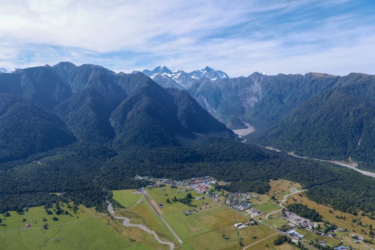
Franz Josef township is built entirely around the glacier. Hotels, heli-hike operators, a supermarket, and a bar called the Blue Ice that had a sign outside advertising “$10 pizzas on Wednesday.” It was Tuesday. I ate a sandwich I’d made myself and walked to the glacier car park, a ten-minute drive from town, to see the terminal face from the public viewing platform. The glacier has retreated substantially in the last decade — you can see it in the wide, grey valley it left behind, a scar of bare rock and sediment stretching back toward the ice. “It used to come right down to where we’re standing,” a guide told me. She was leading a small group of Japanese tourists and had stopped at the platform to let them take photos. “My father remembers walking on it from this car park. Now it’s a forty-minute hike to the toe.” She said it without particular emotion, as if reporting a weather fact, then her group moved on and I was alone again.
The glacier walk itself — the public track, not a guided ice hike — is a straightforward path through valley floor that ends at a roped-off area maybe 500 metres from the ice. The river below the glacier runs milky-grey with rock flour, and the sound of it is constant, a low grinding that I realised later was probably rocks tumbling underwater. I stood at the rope and watched a piece of ice the size of a small car calve from the face and fall into the meltwater pool below. The sound arrived half a second after the sight, a crack like a rifle shot echoing off the valley walls. Nobody else seemed to have noticed. The Japanese group was already walking back toward the bus.
That night I drove the twenty minutes south to Fox Glacier, the smaller and less commercialised of the two glacier towns, and parked at a freedom camping spot near Lake Matheson. The freedom camping rules on the West Coast are specific and enforced — certified self-contained vehicles only, which my rental was, and no overnight parking within 50 metres of a lake shore. I found a spot on a gravel pullout behind a hedge of gorse, with a view of nothing in particular, and made tea on the camp stove while the light faded. A french couple in a converted van pulled in beside me, and we exchanged the small talk of people who have chosen the same obscure parking spot: where from, how long, did you see the glacier. They had come from Queenstown, taking the longer route through Haast Pass. “The road is beautiful,” the man said, in accented English. “But the sandflies, my god.” He slapped his forearm to illustrate.
Lake Matheson at dawn is one of those experiences that has been photographed so many times — the mirror reflection of Mount Cook and Mount Tasman in still water — that I nearly skipped it. I’m glad I didn’t. The track around the lake is an easy hour, boardwalk in places, and at 6:30 a.m. I shared it with exactly three other people: a solo Japanese man with a tripod, a woman jogging, and someone who might have been a Department of Conservation worker checking a signpost. The reflection was perfect. Not good-for-a-photo perfect but genuinely perfect, the kind of symmetry that makes you question whether your eyes are working correctly. The water was so still that the mountains looked painted on glass. I stood at View of Views — the lookout’s actual name — and watched the colour inch from grey to pink to pale gold as the sun came up, and I didn’t take a single photo. The Japanese man took many. We nodded at each other and went our separate ways.
The Haast Pass road, State Highway 6 from the West Coast toward Wanaka, is the kind of drive that accumulates in your memory as a series of specific moments rather than a continuous route. The Blue Pools, a thirty-minute walk from the road, are exactly as advertised — two pools of water so clear that the trout visible at the bottom seem to be floating in air. I stood on the swing bridge above them, watching a family toss breadcrumbs to eels that materialised from the shadows, and thought about how many times this exact scene has been captured on someone’s phone. The trailhead car park was full when I arrived at 10 a.m. I waited fifteen minutes for a spot, walked the track, and left feeling that I had seen exactly what I was supposed to see — no more, no less.
What made the Haast Pass memorable was not the famous stops but the anonymous ones. A pullover at the Gates of Haast, where the river crashes through a narrow gorge, and I watched for ten minutes without a single other car stopping. A bridge over the Makarora River where I ate a bruised apple and watched a jetboat roar past, its wake dissolving into white water. A stretch of road where the beech forest closed in so tight that the light turned green and dappled, and I rolled down the window just to smell the damp bark and leaf litter. These moments don’t have names. They don’t appear on the laminated map from the rental desk. You remember them anyway.
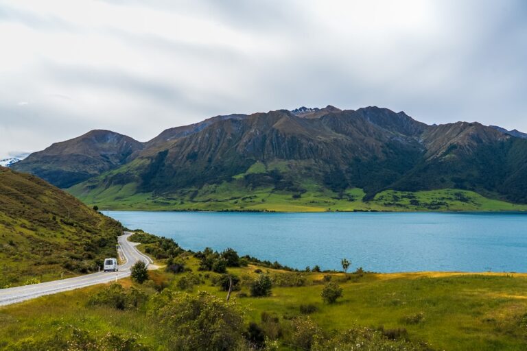
I arrived in Wanaka at 3 p.m., tired, hungry, and in need of a shower. The lakefront was crowded with the usual summer traffic — families, cyclists, a man juggling flaming torches for tips — and I found a parking spot near the town centre after only two circles of the block. I bought a flat white from a cafe whose name I’ve already forgotten, sat on a bench by the water, and watched a dog chase a stick into the lake and back, over and over, never seeming to tire of the exchange. The lake was the same impossible blue as the photographs I’d seen, but the difference between a photograph and being there is that a photograph doesn’t include the wind on your neck, the specific temperature of the coffee through the cardboard sleeve, or the brief eye contact with the dog’s owner, a woman in a fleece who smiled and said, “He’ll do that all day if you let him.”
I had planned to push through to Queenstown the next morning, three hours south, but I didn’t. I booked a non-powered site at the Wanaka Kiwi Holiday Park for $15, spent the evening walking the lakefront as the light faded, and ate fish and chips from a takeaway shop that a local had recommended — $14.50 for a piece of blue cod and a scoop of chips, wrapped in paper, eaten on a dock with the mountains turning purple across the water. The plans you make in

📷 Photos: Donovan Kelly (Pexels), Chen Te (Pexels)