Where the Maps End, the Riding Begins
Where the Maps End, the Riding Begins
The northern loop through Ha Giang has been written about so many times that the secret is no longer a secret. By 2024, more than 300,000 foreign visitors made the trip — a number that has nearly doubled in three years. Almost all of them took the same route: the Ma Pi Leng Pass, the Dong Van Karst Plateau, the Lung Cu Flag Tower. Almost all of them came back with similar photos.
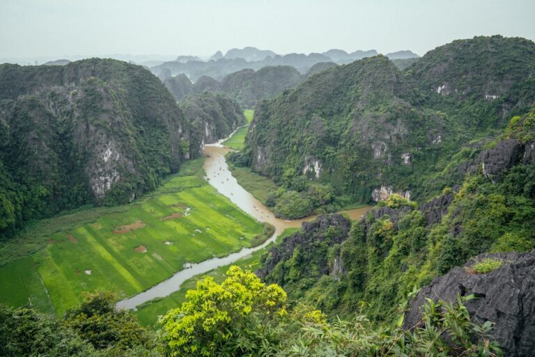
But the province is roughly the size of Connecticut, and the famous loop accounts for maybe a third of its paved roads. Beyond it, a network of smaller provincial routes and unpaved tracks leads into valleys that don’t appear on Google Maps, let alone in any guidebook. The rice terraces there — the ones that aren’t photographed, aren’t advertised, and aren’t maintained for tourists — require a different kind of journey.
It starts with getting the right bike. The Honda XR150, a common rental choice in Ha Giang City, is light enough for single-track dirt paths and tall enough to clear the ruts left by overloaded trucks in the wet season. Rental prices in late 2024 ran about 250,000 to 400,000 Vietnamese dong per day — roughly $10 to $16 — depending on the condition of the tires and whether the suspension had been replaced within the last year. Most travelers don’t check the suspension. They should.
Reading the Terrain, Not the Map
The first mistake most riders make is trusting their phone. Cellular service drops unpredictably once the road leaves the main loop — sometimes for twenty minutes, sometimes for an entire afternoon. A local SIM card helps, but not enough. “The phone shows a road,” says Tran Van Duc, who has been repairing motorcycles in the town of Meo Vac for twenty-two years. “It doesn’t show whether that road was washed away last month.”
Duc’s shop is a concrete room with a corrugated roof and a dirt floor stained with years of engine oil. He learned his trade in Hanoi, then came home. He estimates he fixes five to eight tourist bikes per week during peak season, most of them brought in on the back of a truck after a rider tried a road that didn’t exist anymore.
The practical alternative: navigate by landmark and by asking. A small notebook with Vietnamese phrases for ruộng bậc thang (rice terrace), đường đất (dirt road), and có đi được không? (is it passable?) costs nothing and works better than a SIM card. The terrain changes fast enough that a local farmer will know more about the current condition of a certain path than any source published online.
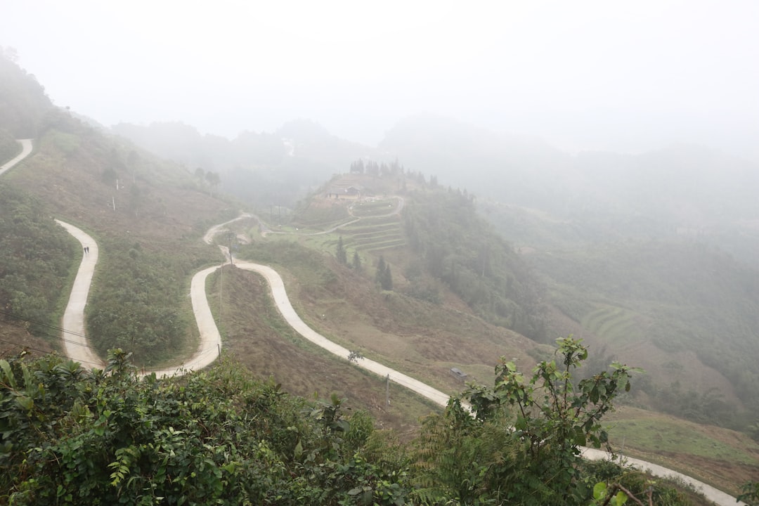
The Road to No Address
One of the better unmapped routes cuts east from the town of Yen Minh toward the Chinese border, then swings south through a valley that doesn’t have a name in any language spoken by tourists. The road surface shifts from asphalt to packed earth to loose gravel within a few kilometers. A dry-season rider can make it in about three hours from the main road. A wet-season rider might not make it at all.
At the valley floor, a cluster of Hmong and Tay villages sits along a stream that feeds into the Gam River. The terraces here are not the sculpted, famous ones of Mu Cang Chai or Sapa. They are narrower, steeper, and older — carved by hand, family by family, over decades. The farmers do not charge admission. There is no viewing platform, no souvenir stall, no place to buy a bottle of water. The rice grows, the water flows through bamboo pipes, and the only sound is the occasional dog barking from a house on stilts.
A visitor who arrives in late September, when the terraces are golden before harvest, will find something the brochures don’t describe: the smell of ripening rice mixed with woodsmoke and the faint mineral tang of the stream. It is not a staged experience. It is a working landscape.
What Costs What
A bowl of phở chua — the sour noodle soup of Ha Giang’s ethnic minorities — costs 20,000 dong (about 80 cents) at a roadside stall in the village of Du Gia, where the owner’s granddaughter translates the menu from Hmong into basic Vietnamese. A can of local beer, if the stall has it, costs 10,000 dong. A liter of gasoline from a plastic bottle sold by a house with a hand-painted sign costs about 25,000 dong — slightly more than at the official pumps, but available on Sunday afternoon when the nearest station is forty kilometers away.
The real cost is time. A rider who leaves Ha Giang City at 8 a.m. hoping to reach the unmapped valley by lunch will be disappointed. The roads demand a different speed — not the 40 km/h of the main pass, but the 15 km/h of a surface that requires constant attention to ruts, rocks, and the occasional water buffalo. A seventy-kilometer stretch of unpaved road can take five hours. Many riders underestimate this by a factor of two.
The Mistake That Costs a Day
A French traveler named Julien arrived at Duc’s repair shop at dusk with a broken clutch cable. He had tried to push his bike up a steep, rocky section of road in second gear instead of first, then downshifted too late. The cable snapped fifteen kilometers from the nearest town. He walked for three hours to reach the main road, hitched a ride on a cargo truck, and spent the night in Meo Vac waiting for Duc to open in the morning.
The spare cable cost 80,000 dong. The towing, the missed day of riding, and the hotel room cost significantly more — in money, but also in the itinerary he had to abandon. “I had to skip the entire eastern part,” he said later, sitting on a plastic stool outside Duc’s shop. “I saw the loop, but not the thing I came for.” He meant the off-map terraces. He never made it there.
Duc keeps a box of spare clutch cables under his workbench, along with extra brake pads and a coil of steel wire. He sells them at cost to travelers who made the same mistake. “They always think it won’t happen to them,” he said, without judgment.
When the Light Changes Everything
Most visitors to the unmapped terraces arrive in the middle of the day. That’s when the light is harsh and flat, and the terraces lose the depth that makes them look like stairways to something. The better time is late afternoon — around 4:30 p.m. in September, when the sun drops behind the western ridge and the rice catches a low, golden angle that turns the whole valley into a reflector.
But that timing creates a different problem: getting back before dark. The roads that felt manageable at noon become treacherous in twilight, when shadows erase the distinction between a puddle and a pothole. A rider who stays for the good light must either camp in the valley — which involves asking a family for permission, a gesture usually met with hospitality — or know the route well enough to ride it by feel.
The families in the valley are used to occasional visitors. A traveler who arrives with nothing more than a sleeping bag and a phrase or two of Vietnamese will often be offered a corner of the stilt house, a mosquito net, and a meal. The etiquette: offer payment, accept refusal twice, insist once. If the family accepts money, it will be a modest amount — 50,000 to 100,000 dong. If they refuse, thank them and leave a small gift, like a bag of rice or a packet of instant coffee, which is more useful to them than cash they will have to carry to a market thirty kilometers away.
The Roads That Don’t Forgive
The biggest difference between riding the main loop and riding the off-map routes is the margin for error. On the main loop, a breakdown means waiting for another tourist to pass. On the secondary roads, it means walking — sometimes for hours, through terrain where the temperature drops sharply after sunset and a ankle injury in the wrong place would become a serious problem.
The solution is not better equipment. It’s preparation: a tool kit with the right socket wrench sizes for the XR150, a spare tube or at least a patch kit, a headlamp with extra batteries, and enough water for two people for one day. A first-aid kit that goes beyond adhesive bandages — ace wrap, antiseptic, a small pair of tweezers for embedded gravel. These items weigh about two kilograms total. They are the difference between an inconvenience and an emergency.
And they are the difference between seeing the terraces that don’t appear on any map and coming home with the same photos everyone else has.
A rider who makes it back by dark, with rice dust still caught in the oil of the bike’s engine fins, will have a story that won’t fit into a postcard. Whether that’s worth the risk of a snapped cable or a wrong turn in the twilight — that’s a question each traveler answers alone, usually after the next rainy season has already washed out half the roads they had planned to try.
📷 Photos: Phương Anh Nguyễn (Unsplash), Dung Doan (Unsplash)